The Blackwater Death Site: Where were Morton, Baker, and McCloskey Killed?
I.
After 140 years, the circumstances that lead to the deaths of William ‘Buck’ Morton, Frank Baker, and William McCloskey remain a mystery. We know that they were arrested by Brewer’s posse on the Pecos near Seven Rivers on Friday, March 8, 1878, and after spending the night at John Chisum’s South Springs Ranch, the prisoners were taken up an old military road to Blackwater Canyon, ostensibly to be delivered to Lincoln. We know that they never made it. The story is that Morton, Baker, and McCloskey were shot down, either in cold blood or during an escape attempt, or perhaps a mix of both. Multiple accounts claim the victims were buried near where they fell and that the location of those graves has been lost. But that’s not the whole story.
There is still the question of where they fell. In what vicinity? There has been a tendency among researchers to place it at or adjacent to the springs. However, the evidence suggests that the killings took place somewhere else, somewhere specific. The following analysis corelates the Regulator’s accounts of the killings with the local geography in an attempt to geolocate, as closely as possible, the death site and potential grave sites.
A deterrent to geolocating the site of the 1878 murders is the confusing nomenclature relative to the geographic area of Blackwater Canyon. Place names are fluid between statements and individuals. Originally called ‘Agua Negra’, and later Anglicized to ‘Black Water’, the spring, the creek, and the canyon all share the same name. And both Spanish and English versions are used. ‘Canyon’ is sometimes replaced by ‘draw’, just as ‘spring’ is sometimes replaced by ‘hole’. The road along the creek also shares the name, and there are times when the entire watershed and geographic region is referred to as ‘Black Water’ or ‘Agua Negra.’ While the onomastic redundancy can be confounding, a careful reading shows the contemporary testimony does indeed put a mark on a map.
The statements of Sallie Chisum, Buck Morton, Ash Upson, and Martin Chavez provide a credible timeline of the Brewer party’s movements on Saturday, March 9th, 1878; at least until the moment they exited the main road onto the military road through Blackwater Canyon. That crossroads at Six Mile Hill, six miles west of Roswell, is where the mystery begins. Only the men who rode the trail that day knew the truth, and they’re all dead. But, while what happened has been lost to the ages, where it happened may still be revealed. A study of the local geography compared with contemporary witness testimony helps shine a light on the likely locale for where the shooting popped off. In other words, by visually superimposing the accounts of those present onto the landscape, we can try to geolocate the potential vicinity of the killings.
II.
Looking at the witness testimony from 1878, mileage was given in reference to both Lincoln and Roswell. Blackwater Spring was used as a waypoint.
“When we had ridden some 20 miles [from Roswell], and had reached a point some 5 or 6 miles from Black Water…” – Frank McNab, via Ash Upson, Mesilla Valley Independent, March 10, 1878
“… when within 30 miles of Lincoln…” – Richard Brewer, via Alexander McSween, Angel Report Witness Statement, June 6, 1878
“When within 25 miles of the town of Lincoln…” – John Middleton, Angel Report Witness Statement, June 13, 1878
“… near Black Water.” – Henry Brown, Angel Report Witness Statement, June 13, 1878
To approximate on a map the mileage described by the 1878 witnesses, a composite with Google Earth satellite imagery was made. Two concentric circles- one inner circle representing a 20-mile radius and one outer circle representing a 30-mile radius- were drawn around both Lincoln and Roswell; each town’s pair representing a 20–30-mile radius. These four circles create a Venn diagram across the landscape. Where the circles intersect is an area of interest that best fits the 1878 descriptions of the murder site.
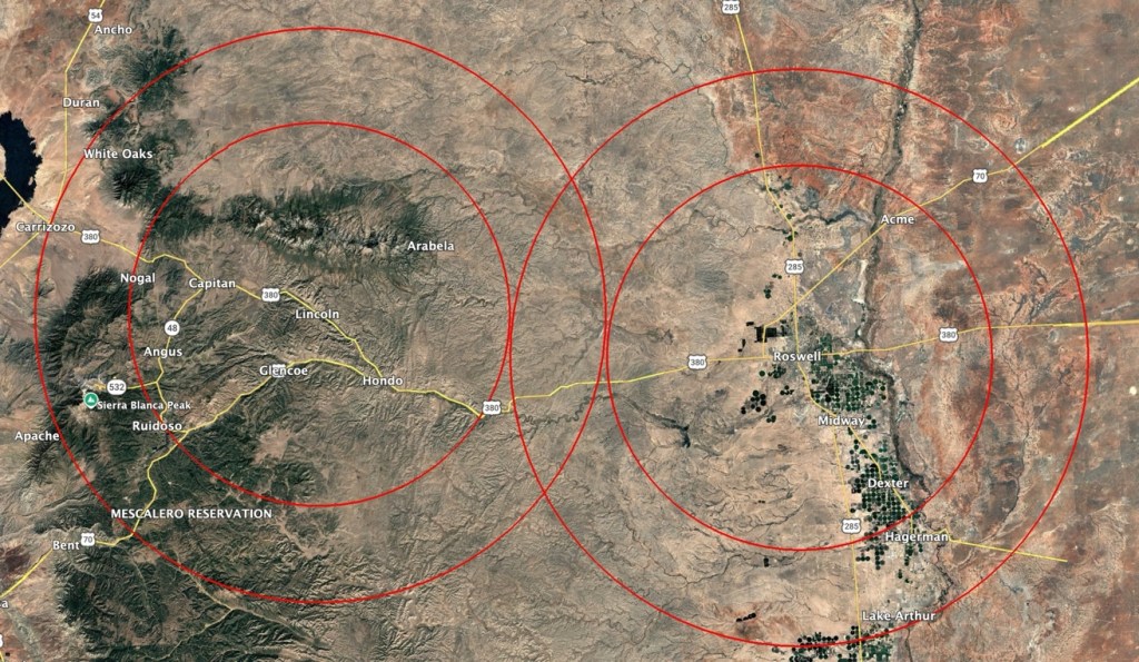
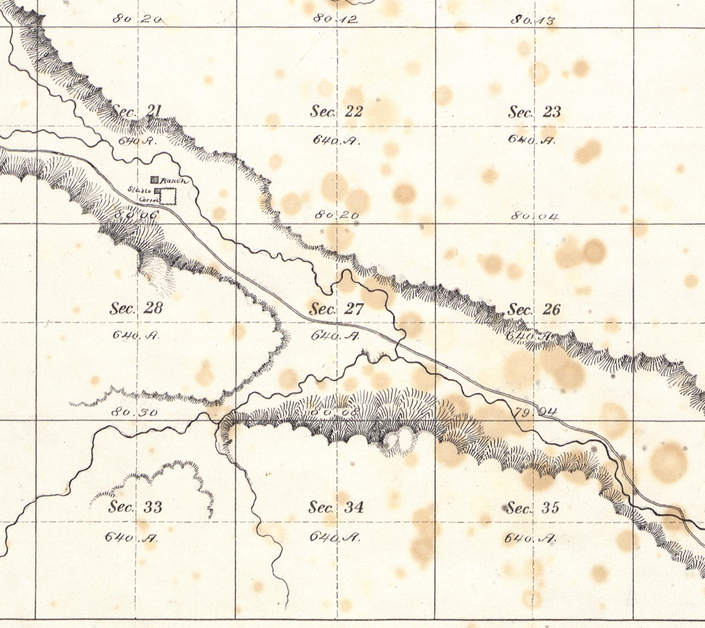
The old military road that the Brewer party took into Blackwater can still be found on 19th century surveys. It followed Blackwater Creek up Blackwater Canyon, passing directly through the area of interest on the 1878 composite map. None of the contemporary accounts placed the affray at the springs, which fall outside of the area of interest formed by the Venn diagram.
III.
Second and third-hand information about the massacre was given by local pioneers and researchers in the years that followed. These reinforced the geography of the 1878 testimony and included additional details that added resolution.
“About 20 or 30 miles from Roswell, near the Black Water Holes…” – Pat Garrett, Authentic Life of Billy the Kid, 1882
“… at a point near the Agua Negra…” – Emerson Hough, The Story of the Outlaw, 1907
“Morton and Baker were murdered at Agua Negra… As the posse approached Black Water Spring…“ – Walter Noble Burns, The Saga of Billy the Kid, 1926
“… halfway between 13 Mile Lake and Blackwater in a pretty little valley.” – John Meadows, Pat Garrett and Billy the Kid as I Knew Them, 1931
“This occurrence took place at Dead Man’s Hole, about 30 miles northwest of Roswell, on the Lincoln-Chaves Counties line.” – George Coe, Frontier Fighter, 1934
“About 25 or 30 miles from Roswell, near Agua Negra Spring…” – Miguel Otero, The Real Billy the Kid, 1936
“… a place about 5 miles below Agua Negra spring… in what was thereafter to be known as Dead Man’s Draw.” – Maurice Fulton and Robert Mullin, History of the Lincoln County War, 1968
“… in what is now called Dead Man’s Canyon…” – Frederick Nolan, Garrett’s Authentic Life of Billy the Kid Annotated Edition, 2000
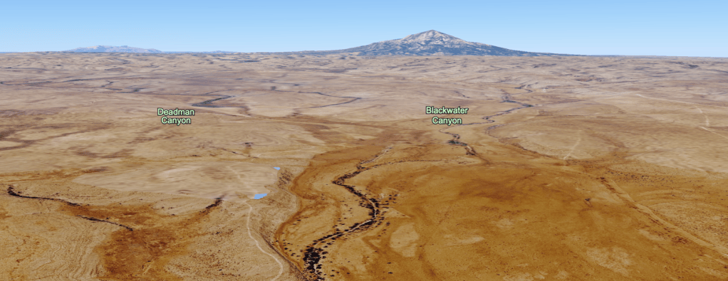
Not only are these later statements consistent with the 1878 testimony, but Deadman Canyon, identified as the vicinity of the killings, is smack dab in the middle of the area of interest from the 1878 testimony composite map. Deadman Canyon intersects Blackwater Canyon and the old military road precisely at this location; a few miles below the springs/ holes and generally halfway between 13 Mile Lake and the latter, just as specified by John Meadows. To support Meadows’ second point, there is a little valley where Deadman Canyon enters Blackwater.
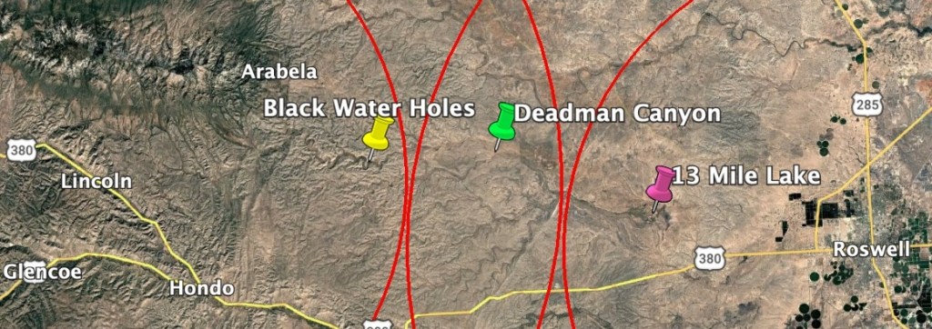
Notable too, is George Coe’s claim that the killing happened near the county line at a place called ‘Dead Man’s Hole’. ‘Deadman Well’ was the name of a tank at the intersection of Deadman Canyon and Blackwater Canyon on USGS maps as recent as 1988. It was only 2 miles from the Lincoln and Chaves County lines, just as described by Coe. Deadman Canyon checked all the boxes.
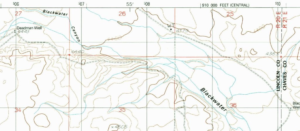
Walter Noble Burns repeated local lore that Morton, Baker, and McCloskey were executed on their knees at the springs proper, but still acknowledged that the ‘regulator’ story claimed otherwise. Aside from the former, which mirrored Dolan’s version of events, there are no credible accounts putting the shooting at the springs themselves. Old timers who outlived the ‘regulators’ came to know the place where the men were killed- and presumably buried- as Deadman Canyon. It was named for the dead men. Hard to ignore the sum of evidence pointing directly at this area as the scene of the shooting. The intersection of Blackwater and Deadman Canyon is the most plausible location for the death site, based on testimony from witnesses and those who knew them.
IV.
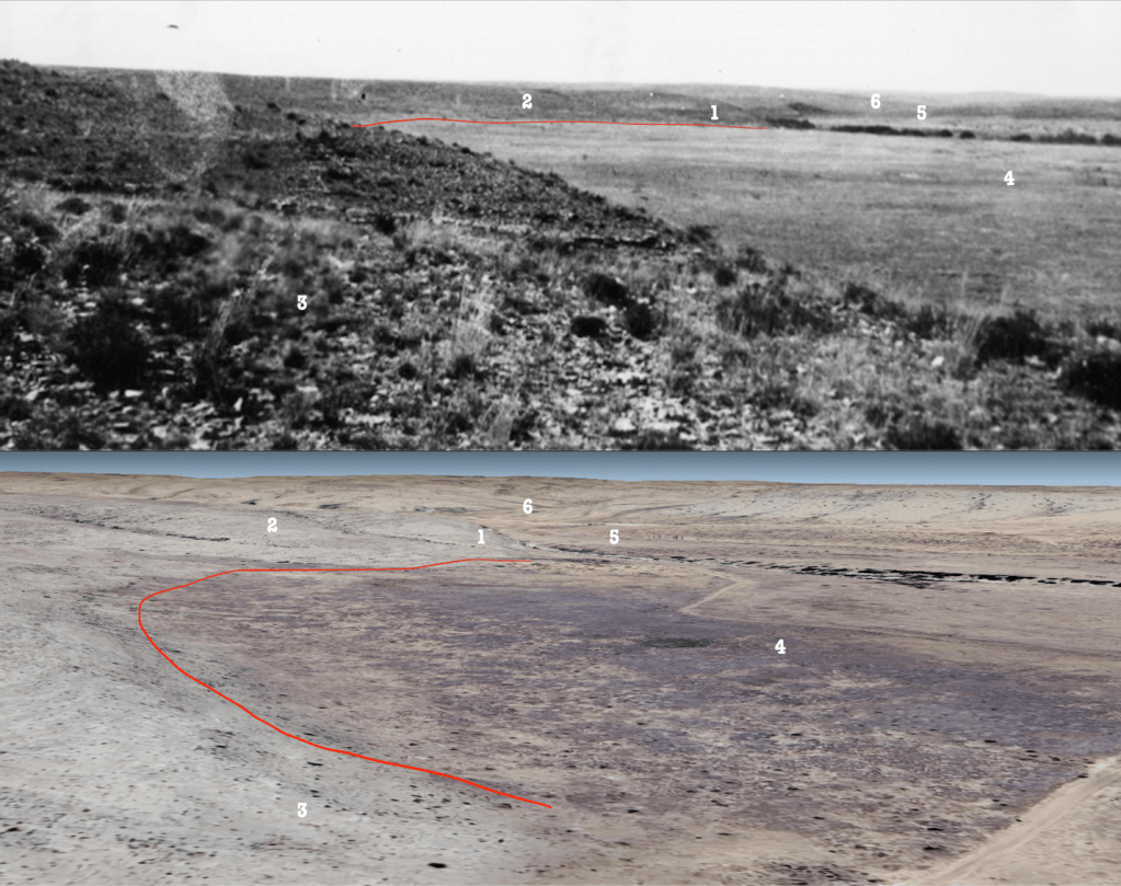
In July of 2025, Billy the Kid’s Historical Coalition shared an unidentified photograph under the presumption that it was of the springs. It was labeled on the reverse: “Scene of the killing of Morton, Baker, and McCloskey. Near the Blackwater holes west of Roswell.” Having spent hours navigating Google Earth and old maps of the area during the analysis of witness testimony, something was immediately familiar about the landscape captured in the photograph. It was not a picture of the springs. It was John Meadows’ “pretty little valley.”
It did not take long to geolocate this photo. It was a picture of the little valley at the intersection of Blackwater and Deadman Canyons. A piece of evidence coming directly from Fulton, corroborating all credible accounts of the whereabouts of the shooting; including the Venn diagram composite map. This discovery was immediately shared with BTKHC.
Josh Slatten, of the Coalition, revealed that the photo was found in the collection of researcher Col. Maurice Fulton. An authority like Fulton arriving at the same Deadman-Blackwater neighborhood, lent credence to the authenticity of the location as the death site. As the investigation continued, other Fulton photographs of the Blackwater area were geolocated. It became clear that Fulton was on the trail of the ‘regulators’ that day, and his documentation at Deadman and Blackwater Canyon, as well as his captioning of it as the murder site, supported all credible testimony and reinforced the supposition that Morton, Baker, and McCloskey were not killed at the springs, but in a pretty little valley.