NO WAY, CROQUET
The Croquet Billy Photo vs. The Flying H Schoolhouse
“We’ve done our work to prove this photo is real. If you disagree, stand up and show us the proof why it isn’t.” – Jeff Aiello, Co-Executive Producer, “Billy the Kid: The New Evidence”
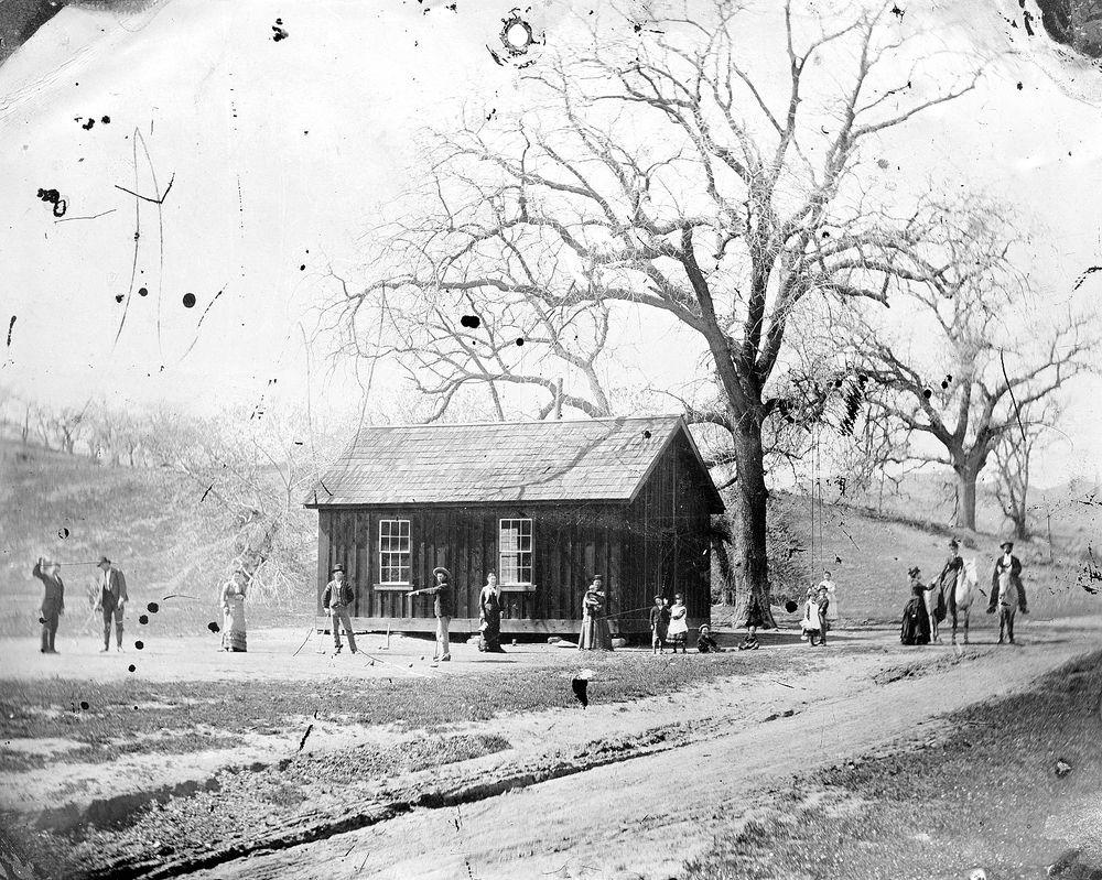
While other researchers have successfully used documentary evidence to rule out any prospect that the Croquet Billy Photo was legit, the following is a pseudo-topographical and pseudo-mathematical analysis of the same. A qualified scientist could nail this down ten times better, but this is really a case of believing your own eyes. Most of what follows is just observation of the topography and therefore requires some speculation. An attempt is also made to measure the elevation and position of the sun, which is when these methods start to get unusual, and admittedly, potentially dubious mathematically. It is convincing, nonetheless. This analysis does not address any of the documentation, sidesaddle, or tintype image-reversal issues, nor does it attempt to ID any of the subjects, nor have I ever been to either site. What follows is highly conjectural. Beating this dead horse is for entertainment purposes only.
The Flying H Schoolhouse:
The claim. A circa 2011 photograph of the Flying H Schoolhouse on the Rio Feliz, with the Croquet Billy Photo displayed as evidence. Immediately alarm bells should be going off. The buildings are of different materials, shapes, and designs, while the hills and mountains in the background do not match between locations. Let’s look closely.

For the sake of this conversation, it’s important to identify some of the visible topographical features, so everybody is on the same page.
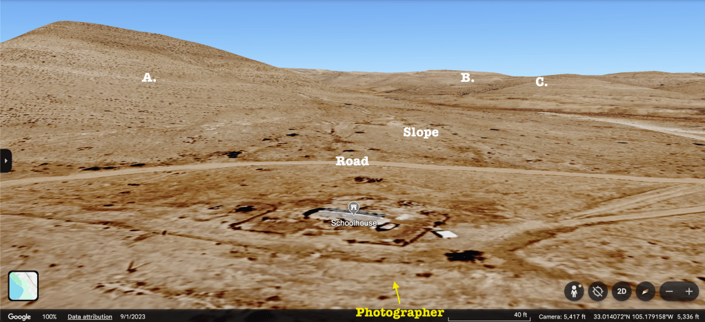
- The large hill to the left and behind (northwest of) the Schoolhouse. Notice how massive it is next to the building. It absolutely dwarfs the Schoolhouse, rising hundreds of feet above it. From the camera’s perspective, the hill falls behind the opposite (northwest) side of the building. This feature is absent from the Croquet Photo.

B. Distant mountain/ hill. A softly undulating ridge in the distant background, disappearing behind a gentle hill (C.), on the right side of the Schoolhouse photo. This feature does not match the Croquet photo.
C. Another distant hill/ mountain with a gentle rise, southeast of B. This feature also does not match the croquet photo.
*Note the position of the ‘Road’ in the midground, before the ‘Slope’ starts to rise significantly. The ‘Slope’ is more of a slant. It has the appearance of a long flat plane at a slight angle. Much different than the rise immediately behind the building of the Croquet Photo.
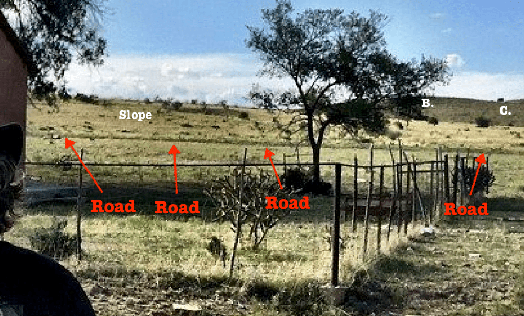
Below: A Google Earth composite shows the relationship between these features on the Schoolhouse site. Note the approximate position of the photographer is southeast of the building, facing northwest. It is inferred that the Croquet Photo is taken from the same vantage point.
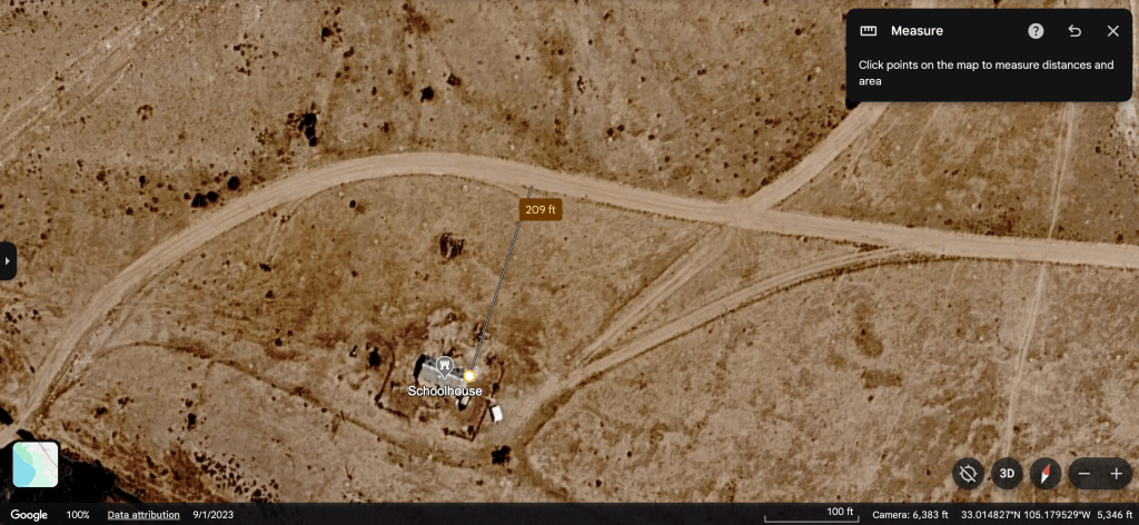
Below: The Road is about 200’ from the north side of the Schoolhouse. Compare this to the steep slope which begins to rise only 10 or 20 yards behind the building in the Croquet Photo.
Below: Google Earth shows the Slope from a different vantage point. This perspective makes it clear just how gradual the rise is at the Flying H. Google Earth estimates an elevation gain of about 40’ over a distance of almost a quarter mile; certainly not the steep rise of the hill directly behind the building in the Croquet Photo.

The Croquet Billy Photo:
Below: The Croquet Billy Photo with some of the major differences in topography between the sites highlighted. 1) There is a clear saddle or low point between two hills to the left of the building in the mid-ground. This does not exist in the Flying H Schoolhouse photo or Google Earth satellite imagery. 2) Unlike the Flying H location, the Slope here rises steeply, beginning within 10 to 20 yards behind the building, and gaining elevation much quicker. 3) The jagged mountain ridge in the far background has next to nothing in common with the undulating hills B. and C. of the Flying H, Rio Feliz location.
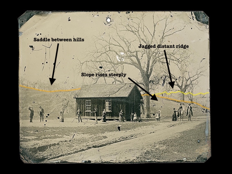
Below: Saddle between hills in distance.

Below: The distant mountain ridge is serrated, not gentle hills like B. and C. The slope in the mid-ground starts to ascend steeply within 10 or 20 yards directly behind the building.

Below: Side by side composite of the two images’ right sides showing the mid-ground slope or hill and the distant ridge. Does anyone actually look at this and think they’re the same place?

Below: Side by side composite of the two images’ left sides and adjacent hillside. Not a match.
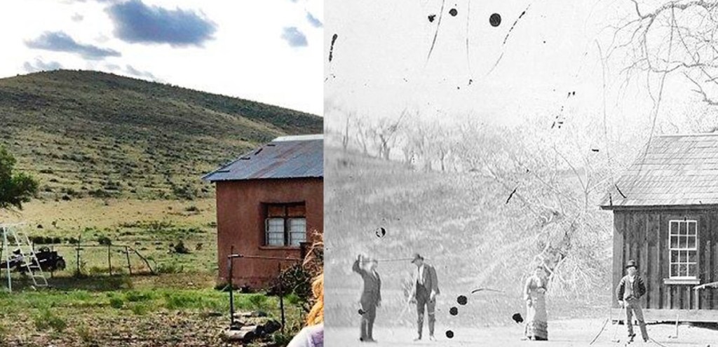
Below: The curved grey line highlights the convex characteristic of the hill behind the building in the Croquet Billy Photo, underscoring its incompatibility with the shallow ‘Slope’ north of the Schoolhouse.

Below: The grey arrows highlight the angle between the subjects and the shadows, revealing the approximate location of the sun. It appears to be high in the sky. This is not exact, but the ground is an X axis, and the shadows point to an approximate Y axis. But there is no apparent Z axis to place the sun with more certainty. Finding the sun might reveal more about the location.
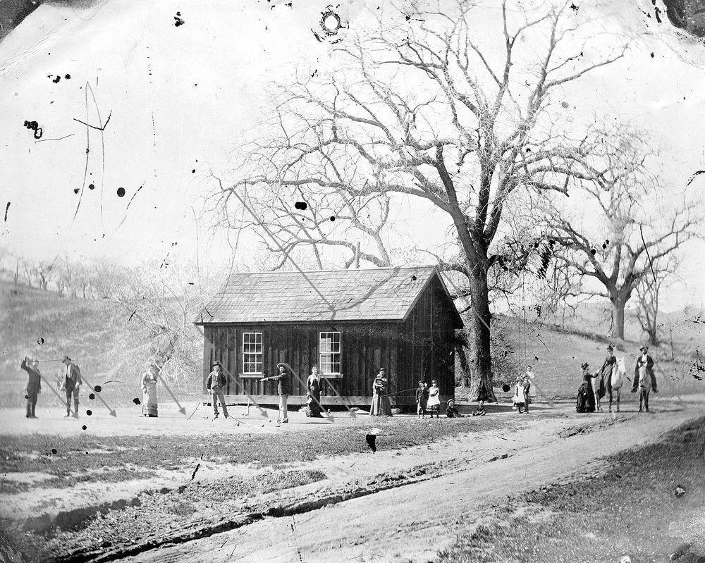
Below: The shadow of the building’s eaves across the board and batten siding gives a slightly more accurate estimate of where the sun is located; assuming the uprights of the building are at 90 degrees. This is not an exact science. These are just estimates based on human-scale and life experience. Taking the length of the shadow down the side of the building and the distance the eave protrudes from the side of the building into account, one can find a clue. Unfortunately, those measurements can only be approximated based on visually interpreting the photo, also known as guessing.

The Solar Calculation:
This solar method of measuring was always a long shot. It is admittedly the weakest part of this argument as it is the most speculative. The true location of the Croquet Billy Photo is not known and therefore cannot be measured on Google Earth the way the Flying H Schoolhouse can be. The only option is to guess. And it should be said that the following measurements and dates were bracketed; meaning, inputs were given at both slightly longer and slightly shorter distances for the eaves and shadows, as well as with the extended dates of August 1 through August 31, 1878. The results varied but all remained within a reasonable ballpark to approximate the sun’s position.
Looking at the Croquet Billy Photo, the eaves were estimated as extending about 9” out from the outer wall of the building and the eave’s shadow extending about 36” down the same outer wall, from a point equal in height to the outer edge of the eave, to a point down and across the window panes near the second mullion from the top. Plugging in those numbers, trigonometry gives an angle of approximately 70 degrees for the elevation of the sun in that photograph. Again, this all presumes the building is level. 70 degrees is an approximate baseline for the solar elevation in the Croquet Photo. This needs to be compared to the sun’s position at the Schoolhouse back in August of 1878. This can easily be done since we know the location of the Schoolhouse on the Rio Feliz.
Punching the coordinates of the Flying H Schoolhouse into a couple NOAA solar calculators, gives a solar elevation of about 71 degrees at noon on August 15, 1878. Of course, the exact date and time of day will affect the elevation accordingly, but without a huge variation over the course of a week or two. Again, these are just estimates.
Interestingly, the solar elevation of 71 degrees is a close match to the suspected time and place of the Croquet Photo. Importantly, however, the solar azimuth does not match. And here’s why.


While the solar elevation (El) measures how high the sun is above the horizon, the solar azimuth (Az) is a measurement of the sun on a N-S-E-W scale. Starting at 0 degrees in the North and moving clockwise through 90 degrees (east), 180 degrees (south), 270 degrees (west), and back to 0. According to NOAA solar calculators, using the coordinates for the Schoolhouse, at noon on August 15, 1878, the solar azimuth was about 176 degrees. That is just east of due south. That means that if the Croquet photo was taken at the Flying H Schoolhouse in August of 1878, by the time the sun reached an elevation of 70 degrees, it would have been shining from behind the photographer, or just over his left shoulder. It would have cast shadows away from the camera. The building’s shadow would have fallen out of sight behind the building itself. Of course, there’s a ton of wiggle room here, but not quite enough to make it go any other way. We know that the long outer wall of the Schoolhouse that faces the camera in the Flying H photo is the south side. The inference being that the Croquet Photo’s building’s wall (that faces the croquet pitch and the camera) likewise, is the south side. But is it?
Below: Google Earth image of Flying H Schoolhouse showing that it sits aligned on an east west axis with the south wall being the one photographed from the southeast.
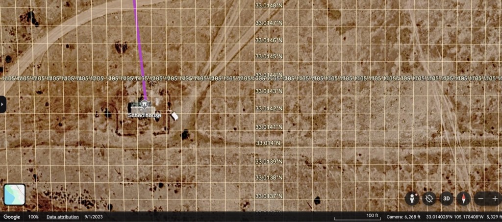
Back to the azimuth, given the estimated 70 degree solar elevation derived from the Croquet photo, in addition to the direction the shadows fall, the solar azimuth of the Croquet photo appears to be far to the west. Too far to the west. So far to the west in fact that the sun could not possibly have had such a high elevation at that position and time. The only conclusion is that the sun in the Croquet Billy Photo is not in the west, but in the south. The building’s wall facing the croquet pitch and the camera in the Croquet photo is likely not the southern wall, as inferred by the Schoolhouse photo, but more likely the eastern wall. These are not the same locations.
And further, if the time of year is winter or a shoulder season, as the amount of foliage suggests, then it is even more likely an easterly wall, as the sun wouldn’t elevate as high as 70 degrees in the east or west during the winter months. With that in mind, scrutinizing the trees further reveals a density of branch growth on that same side of each tree, which is characteristic of the southern exposure of most every tree canopy in the northern hemisphere. It is, however, always possible this photograph was taken in the southern hemisphere.
There are so many obvious inconsistencies between these two locations, just by looking at the photographs, it is surprising how few people trust their own eyes. The above calculations and estimates regarding the Croquet Billy Photo are not intended to be exact, but instead they provide a ballpark interpretation of a century old photo of unknown provenance. These approximations might be considered ‘armchair’ or ‘lunatic fringe’ compared with the solid documentary evidence provided by researchers like Mark Boardman and Corey Recko. But these eyes are convinced that these are two completely different and separate locations. If you’ve read this far, thank you. This is a good place to stop and go back and compare these two photos again.
July 18, 2026

